

Activities & Alerts
With the threat of Tropical Cyclone Alfred tracking towards SEQ and forecast to make landfall from Thursday onwards, it is extremely important that we prepare our projects the best we can.
If all projects between Bundaberg and Byron Bay could today start the process of storm / cyclone preparations.
This should be completed and documented using the Inspections > Site Shut Down - Cyclone Preparation Checklist F-084-C tab located on HammerTech.
Please note, any project that has an erected tower crane will also need to ensure they have updated documented advice from their crane engineer outlining the correct weathervane radius, this should be specific to your project.
Hutchies' owned and managed cranes can coordinate this through Bradley Beck, all third party supplied cranes will need to actioned with their nominated representatives.

Any questions please call Jimmy Andersen on 0400 220 381 to discuss.
Every project needs to be prepared for the Christmas holiday shutdown.
Sites must be secure and ready for any potential weather events during the shutdown period.
All projects need to prepare, plan and coordinate the implementation of Hutchies' shutdown and storm preparation processes prior to the break.
This includes:
- Ensuring plant, amenities, temporary structures and perimeter fencing is secured with the relevant site contacts for the break displayed on the perimeter fence
- Ensure external areas / works are secure and have controls in place as per erosion sediment control plans
- As a Project Team, ensure there is a communicated plan to attend the project during the break for emergencies
- Checking that open excavations and trenches have been filled or barricaded
All shutdown checklists are to be completed on HammerTech > Inspections: Site Shutdown Storm Preparation Checklist (F-084)
BOM is forecasting a warm summer ahead for Australia. Previous data shows there will also be wet days.
Make sure to account for wet weather in your prelims and ensure your contracts include clauses for delays due to extreme weather events. Also, have a plan to manage risks from high winds, heat, and smoke.
We’re not the only ones who party over the break. Mother Nature is known for getting rowdy over Christmas, dishing out some severe weather and environmental events.
Ranging from high winds, heavy rain, flooding, hail and in some cases cyclones, these have the potential to cause damage to Hutchies' sites, and adjacent properties and assets.
Since the beginning of 2022, our sites have already braved significant wet weather, and the forecast predicts more to come.
To best prepare for these potential weather events and to keep our sites secure, every project needs to fully implement Hutchies' shutdown and storm preparation processes prior to the holiday break.
This includes:
- Ensuring plant, amenities, temporary structures and perimeter fencing is secured with the relevant site contacts for the break displayed on the perimeter fence
- As a Project Team, ensure there is a plan to attend the project during the break for emergencies
- Checking that open excavations and trenches have been filled or barricaded
- Sediment and erosion controls are in place on the boundaries and around any soil stockpiles that could potentially cause impact to the environment
- Consideration of insurance requirements for weather and flood mitigation
All shutdown checklists are to be completed on HammerTech > Inspections: Site Shutdown Storm Preparation Checklist (F-084)
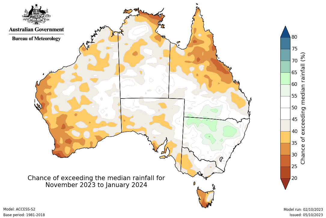
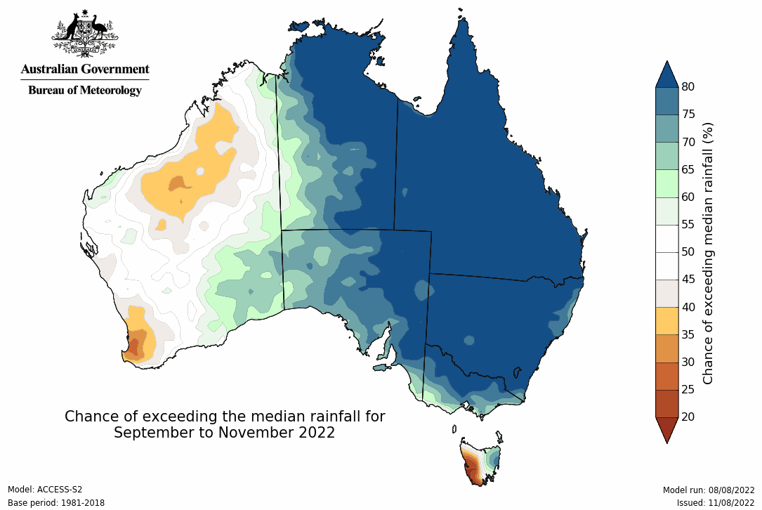
BOM continues to forecast above average rainfall across eastern and central Australia for the next six months.
Make allowances for wet weather in your preliminaries, ensure contracts have provisions for extreme weather related time and cost delays, and have risk mitigation plans in place to prevent impacts from bad weather or flooding on sites for insurance purposes.
Potential Impact
We typically see around 15% of wet weather days per annum. The 2022 weather events have seen this jump up to 38% in some areas like NSW. It's important to have plans in place from a contractual perspective, and risk mitigation strategies on sites to minimise impact of weather and flooding.
Key Resources
Ensure our sites are ready in the event of bad weather. Our recent insurance policy changes requires all of Hutchies' sites to demonstrate that they have considered the risk and impact of weather and flooding.
Contract Clauses
Hutchies' head contracts on the Toolbox includes inclement weather as a qualifying cause of delay.
If you're not using a standard Hutchies head contract, ensure inclement weather is a qualifying cause of delay. The Contracts Review Team can assist with drafting.
Programming
Where your contract doesn't entitle you to an EOT for inclement weather, a minimum of 15% delay contingency (in working days) should be factored into current and upcoming programs for inclement weather.
In addition, you should ensure your contract allows you to seek an EOT for 'extreme' weather events by including a qualifying cause of delay such as "any inclement weather which is in excess of the 10-year average weather pattern at the location of the Site."
Tender clarifications should be clear as to what inclement weather risk has been accepted in the program. Anything beyond that allowance will be a claimable qualifying cause of delay.
More Information
Contracts Review
contractsreview@hutchies.com.au
Programming / Owen Lyden
owen.lyden@hutchies.com.au
Overview
With ongoing insurance changes throughout the market, the most recent insurance policy requires all Hutchies' sites to demonstrate that they have considered the risk & impact of weather and flooding on the site. This extends to stored materials, temporary accommodation and other temporary and permanent works. All project teams are required to implement a sensible strategy to minimise this risk with a documented plan that considers:
- the methodology & sequence of works
- reliance on & interface between temporary and permanent works
- the site location & monitoring of weather conditions for the area as a part of daily site management
In the event of a claim, the Project Manager for the site will need to demonstrate there was planning in place that was implemented by the Site Manager, Supervisors and Subcontractors as required.
The insurance requirements are noted in the below ‘Insurance Guidelines' and there is a Hutchified checklist below as well to assist in guiding you through the process.
Please also note the previous alert on protection of people and property.
These events, which range from cyclones, rain, hail, flooding, high winds and bushfires have the potential to cause damage to Hutchies' project sites, and adjacent properties and assets.
Since the beginning of Summer 2021 our sites have already braved significant wet weather, and the forecast predicts a lot more to come.
To ensure we're prepared for these weather events and to keep our sites safe and secure, we need to fully implement Hutchies' shutdown and storm preparation processes prior to the holiday break.
This includes checking that the sediment and erosion controls are in place and effective for any projects where we have open ground and soil stockpiles that could potentially cause impact to the environment.
Hutchies' shutdown checklist is on HammerTech > Inspections:
HB-HSEQ-F-084 Site Shutdown Storm Preparation Checklist
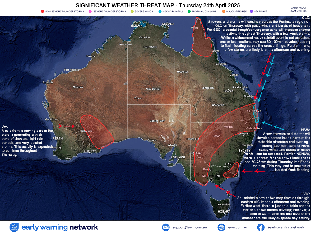
There are currently a number of weather warnings for New South Wales, Queensland and Victoria as a result of extensive rain and now risks of flooding.
Please follow all directions of authorities, stay in the loop with ABC Emergency and ensure Hutchies' site preparation procedures are followed.
Summary of weather
You can also monitor the live radar below for a national summary on the latest weather forecasts.
General advice in storms
- Move cars under cover or away from trees.
- Secure loose outdoor items.
- Seek shelter, preferably indoors and never under trees.
- Avoid using the telephone during a thunderstorm.
- Beware of fallen trees and powerlines.
- For emergency assistance contact the SES on 132 500.
This includes checking that the sediment and erosion controls are in place and effective for any projects where we have open ground and soil stockpiles that have the potential to cause negative environmental impact.
La Niña Event Forecast
2020-2021 Summer Strong Potential for Severe Weather Events
11 December 2020
A La Niña event has been officially declared by the Bureau of Meteorology (BOM) for the Australian summer of 2020-2021.
La Niña typically brings with it heavy rainfall, intense storms and the possibility of strong wind events such as cyclones. The last time Australia saw a fully-fledged La Niña was from 2010 through 2012.
This alert is issued as a reminder to begin preparations for the likelihood of these severe weather events in the coming months.
Of immediate concern is the weather event forecast from tomorrow, Saturday 12 December through Monday 14 December. Those in Northern NSW, the Gold Coast and SE QLD should be prepared for:
> strong winds of ~75 km/hr
> storms and heavy rain
> seas in excess of 6.0 metres Check the Toolbox Weather page or local BOM warnings in your location for more information.
WHAT IS LA NIÑA?
La Niña is a complex weather pattern that occurs every few years, as a result of variations in ocean temperatures in the equatorial band of the Pacific Ocean. It occurs as strong winds blow warm water at the ocean's surface away from South America, across the Pacific Ocean towards Indonesia.
RESOURCES FOR SITE
The below resources are available to assist in the preparation for and in the aftermath of severe weather events. These are also available on the Doc Library and via HammerTech.
Ex-tropical cyclone Trevor is forecast to move southeast from the Barkly district in the Northern Territory and into the Channel Country overnight Monday and into Tuesday. The vigorous low is expected to interact with an amplifying upper trough to produce bands of heavy rain and thunderstorms. Damaging, possibly destructive wind gusts are also expected to develop on the eastern flank of the low.
Widespread six-hourly rainfall totals between 50mm and 80mm are likely within the warning area from Monday afternoon or evening. Isolated heavier and intense rainfall totals up to 120mm are possible with thunderstorms between Urandangi and Bedourie.
Isolated damaging wind gusts up to 100km/h are possible for areas west of Boulia during Monday evening and early Tuesday morning. Locally destructive wind gusts in excess of 125km/h are possible with embedded thunderstorms.
A Flood Watch is current for the western Gulf Country, Channel Country and extending into the Warrego and Maranoa catchments
Locations which may be affected include Birdsville, Boulia, Bedourie, Urandangi, Glenormiston, Davenport Downs Station, Morney, Durrie and Brighton Downs.
Severe Thunderstorms have been detected on satellite over the Carpentaria and northern Barkly in Northern Territory.
Severe thunderstorms are likely to produce damaging winds in the warning area over the next several hours. Locations which may be affected include Borroloola, Mallapunyah, McArthur River, Minyerri and Carpentaria District south of Ngukurr.
Consider all site housekeeping and remove loose waste and material from roofs, scaffold, balconies and open areas (hardstands / laydown) and ensure site fences are well supported with the minimum bracing (every second panel for scrim & every panel for hoarded).
General advice in weather events
- Move cars under cover or away from trees.
- Secure loose outdoor items.
- Seek shelter, preferably indoors and never under trees.
- Avoid using the telephone during a thunderstorm.
- Beware of fallen trees and powerlines.
- For emergency assistance contact the SES on 132 500.
Storms and heavy rainfall are developing over major parts of the East Coast, including Wollongong, Sydney, South East Queensland, Bundaberg, Rockhampton and Townsville. Cairns is experiencing side effects to TC Trevor, which is battering the Cape.
In weather like this, please consider all site housekeeping and remove loose waste and material from roofs, scaffold, balconies and open areas (hardstands / laydown) and ensure site fences are well supported with the minimum bracing (every second panel for scrim & every panel for hoarded).
Summary of weather
Storms are likely across Australia in several regions and cities. Please monitor the live radar below for a national summary.
General advice in storms
- Move cars under cover or away from trees.
- Secure loose outdoor items.
- Seek shelter, preferably indoors and never under trees.
- Avoid using the telephone during a thunderstorm.
- Beware of fallen trees and powerlines.
- For emergency assistance contact the SES on 132 500.
Tropical cyclone Trevor is expected to rapidly re-intensify as it moves over eastern Gulf of Carpentaria waters tonight.
Presently it remains located over land near Aurukun and is currently slow-moving.
The cyclone is expected to move offshore over eastern Gulf of Carpentaria waters tonight, where it is expected to rapidly re-intensify to a category 2 cyclone.
Tropical cyclone Trevor will intensify further as it adopts a more general west-southwest movement across the Gulf of Carpentaria. It is likely to cross the Northern Territory coast during Saturday as a category 4 severe tropical cyclone.
General advice in storms
- Move cars under cover or away from trees.
- Secure loose outdoor items.
- Seek shelter, preferably indoors and never under trees.
- Avoid using the telephone during a thunderstorm.
- Beware of fallen trees and powerlines.
- For emergency assistance contact the SES on 132 500.
People in the path of the cyclone, in particular in the areas between Weipa and Aurukun, should remain inside until the cyclone has passed and listen to the next advice at 8 pm.
People elsewhere in western Cape York Peninsula, between Cape York and Pormpuraaw, should take precautions and listen to the next advice at 8 pm.
People between Pormpuraaw and Kowanyama should consider what action they will need to take if the cyclone threat increases.
Hazards
GALES, with gusts in excess of 90 km/h, are occurring near the centre of the cyclone. GALES are expected to extend to areas between Cape York and Pormpuraaw tonight, including Aurukun and Weipa, as the cyclone moves offshore and intensifies.
DESTRUCTIVE WINDS, with gusts in excess of 130 km/h may develop between Weipa and Aurukun during tonight as the cyclone intensifies.
GALES may further extend south to Kowanyama on the western Cape York Peninsula coast during Thursday night as the cyclone intensifies.
As the cyclone intensifies, a STORM TIDE may occur between Mapoon and Aurukun on tomorrow morning's high tide. Large waves may produce minor flooding along the foreshore. People living in areas likely to be affected by this flooding should take measures to protect their property as much as possible and be prepared to help their neighbours.
HEAVY RAINFALL, which may lead to flash flooding, and DAMAGING to LOCALLY DESTRUCTIVE winds are occurring across parts of the Cape York Peninsula district.
A separate Severe Weather Warning is current for areas between Lockhart River and Laura.
A Flood Warning is current for the Daintree and Mossman rivers as well as a broader Flood Watch for catchments north of Innisfail to Kowanyama.
FOR THE NORTHERN TERRITORY COASTAL AREAS:
GALES, with gusts to 120 km/h are expected to develop on Groote Eylandt from Friday morning and extend to the mainland coast between Cape Shield and the Northern Territory Border later on Friday. GALES could also extend further north to Nhulunbuy on Friday if the cyclone takes a more northerly track.
The VERY DESTRUCTIVE core of Severe Tropical Cyclone Trevor is forecast to cross the southern coast of the Gulf of Carpentaria between Groote Eylandt and Borroloola during Saturday.
VERY DESTRUCTIVE WINDS, with gusts to 250 km/h, HEAVY RAINFALL and a VERY DANGEROUS STORM TIDE are expected near the cyclone centre as it approaches and crosses the coast.
Tides are expected to rise significantly above the normal high tide, with DAMAGING WAVES and VERY DANGEROUS FLOODING near the cyclone centre from Friday night into Saturday.
Severe Tropical Cyclone Trevor continues to move west-southwest towards the eastern Cape York Peninsula coast. It is expected to cross the coast just south of Lockhart River late this afternoon or early evening. The cyclone will most likely cross as a high end category 3 system, but further intensification to category 4 cannot be ruled out.
The cyclone will weaken as it crosses the northern Peninsula tonight and Wednesday, but is expected to remain a category 1 cyclone until it enters the Gulf of Carpentaria later on Wednesday. It is expected to reintensify rapidly once it enters the Gulf of Carpentaria and track towards the Northern Territory.
Consider all site housekeeping and remove loose waste and material from roofs, scaffold, balconies and open areas (hardstands / laydown) and ensure site fences are well supported with the minimum bracing (every second panel for scrim & every panel for hoarded).
General advice in storms
- Move cars under cover or away from trees.
- Secure loose outdoor items.
- Seek shelter, preferably indoors and never under trees.
- Avoid using the telephone during a thunderstorm.
- Beware of fallen trees and powerlines.
- For emergency assistance contact the SES on 132 500.
People between Orford Ness and Cape Melville and adjacent inland areas (including Lockhart River and Coen), should complete preparations quickly and be prepared to shelter in a safe place.
People in western Cape York Peninsula between Mapoon and Pormpuraaw (including Weipa and Aurukun) should immediately commence or continue preparations, especially securing boats and property, using available daylight hours.
Hazards
The VERY DESTRUCTIVE CORE of the cyclone, with extreme gusts up to 220 km/h, will make landfall near Lockhart River later this afternoon.
DESTRUCTIVE WINDS, with gusts in excess of 125 km/h are expected between Cape Grenville and Coen. These DESTRUCTIVE WINDS will move some way inland with the cyclone tonight.
GALES, with gusts in excess of 90 km/h, are expected in coastal areas between Orford Ness and Cape Melville today and tonight. These GALES are expected to extend inland over the Peninsula overnight and on Wednesday as the cyclone moves inland to include areas between Mapoon and Pormppuraaw during Wednesday. Gales are possible later Wednesday further north between Cape York and Mapoon if the cyclone takes a more northerly track than forecast.
As the cyclone crosses the coast, a STORM TIDE is expected between Lockhart River and Cape Melville, including Princess Charlotte Bay. During Wednesday, a STORM TIDE is also expected between Cape Keerweer and Mapoon on the western Peninsula Coast. LARGE WAVES may produce minor flooding along the foreshore. People living in these areas are likely to be affected by flooding and should take measures to protect their property as much as possible and be prepared to help their neighbours.
ABNORMALLY HIGH TIDES are also expected around the Wednesday morning high tide for the far northeast Queensland coast, north of Port Douglas.
HEAVY RAINFALL, which may lead to flash flooding, is forecast across far north Queensland today and continuing over the next few days. A Flood Warning is current for the Daintree and Mossman rivers as well as a broader Flood Watch for catchments north of Innisfail to Kowanyama.
Severe thunderstorms are likely to produce damaging winds, heavy rainfall that may lead to flash flooding and large hailstones in the warning area over the next several hours. Locations which may be affected include Gold Coast, Toowoomba, Brisbane, Dalby, Ipswich, Kingaroy, Coolangatta, Caboolture, Cleveland, Gatton and Jimboomba.
Consider all site housekeeping and remove loose waste and material from roofs, scaffold, balconies and open areas (hardstands / laydown) and ensure site fences are well supported with the minimum bracing (every second panel for scrim & every panel for hoarded).
Summary of weather
Storms are likely across Australia in several regions and cities. Please monitor the live radar below for a national summary.
General advice in storms
- Move cars under cover or away from trees.
- Secure loose outdoor items.
- Seek shelter, preferably indoors and never under trees.
- Avoid using the telephone during a thunderstorm.
- Beware of fallen trees and powerlines.
- For emergency assistance contact the SES on 132 500.
Severe thunderstorms are expected to become more extensive this afternoon and evening. Currently, the primary risks are damaging wind gusts and large hail, however this will transition to heavy rain later this afternoon and evening, particularly across the far southeast.
Severe thunderstorms are likely to produce damaging winds, heavy rainfall that may lead to flash flooding and large hailstones in the warning area over the next several hours. Locations which may be affected include Warwick, Toowoomba, Dalby, Roma, Kingaroy, Ipswich, Gatton, Jimboomba, Laidley, Lowood, Nanango and Tara.
Consider all site housekeeping and remove loose waste and material from roofs, scaffold, balconies and open areas (hardstands / laydown) and ensure site fences are well supported with the minimum bracing (every second panel for scrim & every panel for hoarded).
Summary of weather
Storms are likely across Australia in several regions and cities. Please monitor the live radar below for a national summary.
General advice in storms
- Move cars under cover or away from trees.
- Secure loose outdoor items.
- Seek shelter, preferably indoors and never under trees.
- Avoid using the telephone during a thunderstorm.
- Beware of fallen trees and powerlines.
- For emergency assistance contact the SES on 132 500.
Cyclone / Storm Warnings
All staff Rockhampton to Coolangatta
The map below describes the forecast track for Tropical Cyclone Oma based on information at 05:04 hrs AEST 21 February 2019. The forecast track for TC Oma presents a significant potential hazard for project locations within this path.

Hazards
Abnormally high tides are expected along the southern Queensland coast in the next few days. Seas and swell are also expected to increase well ahead of the approach of Oma. A Severe Weather Warning and Hazardous Surf Warning are current.
What do you need to do?
Please refer to the Hutchies instructions and resources outlined in the Site Shutdown & Storm Preparation Checklist (HB-HSEQ-F-084) and the Storm Preparation video (HE02) available below.
Storm preparedness is to be commenced at the earliest opportunity to ensure that our projects are secure quickly.
Particular attention is required for:
Cranes and masts
Sheet fencing and hoardings
Formwork decks and formwork componentry
Erected scaffold and scaffold componentry
Installation of temporary bracing or other means of securing partially completed structures
Secure all loose material that could become airborne
Available resources to help you be prepared
Checklist / Site Shutdown Storm Preparation (HB-HSEQ-F-084)
- Video / Storm Preparation (HE02)
- Live Radar
- Live Information / Bureau of Meteorology (BOM)
General advice in storms
- Move cars under cover or away from trees.
- Secure loose outdoor items.
- Seek shelter, preferably indoors and never under trees.
- Avoid using the telephone during a thunderstorm.
- Beware of fallen trees and powerlines.
- For emergency assistance contact the SES on 132 500.
We’re not the only ones who party over the break. Mother Nature is known for getting rowdy over Christmas, dishing out severe weather and environmental events.
These events, which range from cyclones, rain, hail, flooding, high winds and bushfires have the potential to cause damage to Hutchies' project sites, and adjacent properties and assets.
Since the beginning of Summer 2018 our Hutchies sites have braved floods, fires, high winds and are shaping up for the first cyclone of the season ‘TC Owen’ which is currently wreaking havoc in Far North Queensland and the Northern Territory.
So for us to be prepared for these weather events we need to make sure that our Site Shutdown and Storm Preparation is fully implemented prior to our holiday break.
This includes checking that the sediment and erosion controls are in place and effective for any projects where we have open ground and soil stockpiles that have the potential to cause negative environmental impact.

Be prepared, listen to authorities and stay safe
As we head into the warmer months, fire safety should be at the front of everyone’s mind at home and on your projects. We’ve prepared a simple list of things to help you be prepared for fire threats.
Stay informed by following local news, listening to your local radio station or keep an eye on your state fire and emergency response services online (ie their website or social media) to stay up to date in what can be fast changing circumstances.
Things to consider and prepare for on your project before the Christmas break and at home
- Have a fire safety survival plan in place, refer to it now and be ready to follow it (SES guides are available here).
- If you don’t have a fire safety plan, or if your plan is to leave, identify where you will go if the situation changes.
- Consider buying or making your own first aid kit with key essentials (a guide is available here).
- Always follow instructions from authorities – it’s for your own safety.
- Clean out and remove any dead leaves, branches and plants in your gutters, and around your property.
- Move any flammable materials such as hazardous substances, doormats, wheelie bins and outdoor furniture away from your property.
- Close windows and doors to minimise smoke exposure.
- If you suffer from a respiratory condition, keep your medication close by.
- Drive with caution in low visibility conditions.
- Contact your neighbours to see if they need help preparing for a fire threat.
- Consider finding your essential items (ie identification documents, prescription medication, food and water, and protective clothing such as a long sleeve cotton shirt and trousers, and boots) in case you need to leave quickly.
- Consider what you will do to protect your pets and / or livestock.
- Drink plenty of water to stay hydrated.
- Advise family and friends of your intended actions if the situation changes.
- If you are in immediate danger, call 000. If your property is damaged and you need assistance, call SES on 132 500.
Local Emergency Services
ACT
NSW
NSW Fire & Rescue / www.fire.nsw.gov.au
NT
NT Fire & Rescue Service / www.pfes.nt.gov.au
QLD
QLD Fire & Emergency Service / www.qfes.qld.gov.au
TAS
TAS Fire Service / www.fire.tas.gov.au
VIC
Country Fire Authority / www.cfa.vic.gov.au
Other Monitoring Services
Australian Bureau of Meteorology (BOM)
News
News / www.news.com.au
Severe Thunderstorm Warning
Severe thunderstorms are likely to produce HEAVY RAINFALL that may lead to flash flooding in the warning area over the next several hours. Locations which may be affected include Gosford, Sydney, Parramatta, Wollongong, Nowra, Ulladulla and Katoomba. Some thunderstorms in the Greater Sydney area are likely to produce VERY HEAVY RAINFALL.
Consider all site housekeeping and remove loose waste and material from roofs, scaffold, balconies and open areas (hardstands / laydown) and ensure site fences are well supported with the minimum bracing (every second panel for scrim & every panel for hoarded).
Summary of weather
Storms are likely across Australia in several regions and cities. Please monitor the live radar below for a national summary.
General advice in storms
- Move cars under cover or away from trees.
- Secure loose outdoor items.
- Seek shelter, preferably indoors and never under trees.
- Avoid using the telephone during a thunderstorm.
- Beware of fallen trees and powerlines.
- For emergency assistance contact the SES on 132 500.
Storm, wind and rain warnings across Australia
Consider all site housekeeping and remove loose waste and material from roofs, scaffold, balconies and open areas (hardstands / laydown) and ensure site fences are well supported with the minimum bracing (every second panel for scrim & every panel for hoarded).
Summary of weather
Storms are likely across Australia in several regions and cities. Please monitor the live radar below for a national summary.
General advice in storms
- Move cars under cover or away from trees.
- Secure loose outdoor items.
- Seek shelter, preferably indoors and never under trees.
- Avoid using the telephone during a thunderstorm.
- Beware of fallen trees and powerlines.
- For emergency assistance contact the SES on 132 500.
Severe storm and rain warnings across parts of Australia
Consider all site housekeeping and remove loose waste and material from roofs, scaffold, balconies and open areas (hardstands / laydown) and ensure site fences are well supported with the minimum bracing (every second panel for scrim & every panel for hoarded).
Summary of weather
- Supercell storms are likely in north west NSW, south east and central QLD today
- Large amounts of rain (up to 30mm today, 110mm for the next four days) in northern NSW and south east and central QLD
- Rain in other parts of Australia including Hutchies' office areas of Sydney, Wollongong, Melbourne, Adelaide, Hobart and Darwin (including vast areas across these states and territories)
General advice in storms
- Move cars under cover or away from trees.
- Secure loose outdoor items.
- Seek shelter, preferably indoors and never under trees.
- Avoid using the telephone during a thunderstorm.
- Beware of fallen trees and powerlines.
- For emergency assistance contact the SES on 132 500.
BOM TOP PRIORITY FOR IMMEDIATE BROADCAST
Severe Thunderstorm Warning for DAMAGING WINDS and LARGE HAILSTONES
For people in parts of Southeast Coast Forecast District and in Northern Rivers and parts of Mid North Coast and Northern Tablelands Forecast Districts.
Keep an eye on the live radar.
Severe thunderstorms are likely to produce damaging winds and large hailstones in the warning area over the next several hours. Queensland locations which may be affected include Brisbane, Ipswich, Boonah, Beenleigh, Beaudesert, Esk, Jimboomba, Laidley, Lowood, Mount Tamborine and Springbrook. In NSW locations include Lismore, Grafton, Coffs Harbour, Ballina, Casino, Kyogle, Yamba, Maclean and Woolgoolga.
Consider all site housekeeping and remove loose waste and material from roofs, scaffold, balconies and open areas (hardstands / laydown) and ensure site fences are well supported with the minimum bracing (every second panel for scrim & every panel for hoarded).
- Move your car under cover or away from trees.
- Secure loose outdoor items.
- Seek shelter, preferably indoors and never under trees.
- Avoid using the telephone during a thunderstorm.
- Beware of fallen trees and powerlines.
- For emergency assistance contact the SES on 132 500.
The next warning is due to be issued by 5:30 pm.
Warnings are also available through TV and Radio broadcasts, the Bureau's website at www.bom.gov.au or call 1300 659 219. The Bureau and Queensland Fire and Emergency Services would appreciate warnings being broadcast regularly.


National Weather Map
A trough has brought powerful wind across South East Queensland.
Consider all site housekeeping and remove loose waste and material from roofs, scaffold, balconies and open areas (hardstands / laydown) and ensure site fences are well supported with the minimum bracing (every second panel for scrim & every panel for hoarded).
#Dust, kicked up by a strong trough that moved through western #Queensland on Friday, has made it all the way to #SEQld on Saturday morning. #Brisbane is looking murky at the moment but it should gradually improve through the weekend.
Thunderstorms and heavy rainfall are expected to hit Sydney and the South Coast this afternoon or later tonight. Keep an eye on the live radar.
Consider all site housekeeping and remove loose waste and material from roofs, scaffold, balconies and open areas (hardstands / laydown) and ensure site fences are well supported with the minimum bracing (every second panel for scrim & every panel for hoarded).
Thunderstorms and heavy rainfall are expected to lash the Gold Coast this afternoon with some large rainfall figures already dropping in the hinterland. Keep an eye on the live radar.
Consider all site housekeeping and remove loose waste and material from roofs, scaffold, balconies and open areas (hardstands / laydown) and ensure site fences are well supported with the minimum bracing (every second panel for scrim & every panel for hoarded).
EARLIER
There is a high probability of a major rain deluge this weekend in the Northern NSW and across South East Queensland regions (as far out as Roma).
The forecast estimates up to 30mm is expected around Roma, St George and along the NSW border. Brisbane and the Sunshine Coast could see falls up to 25mm on Sunday while Gold Coast would be 30mm.
Most of the rain is expected Saturday night / Sunday morning and there is a possible thunderstorm forecast for Sunday.
Consider all site housekeeping and remove loose waste and material from roofs, scaffold, balconies and open areas (hardstands / laydown) and ensure site fences are well supported with the minimum bracing (every second panel for scrim & every panel for hoarded).
There is a possibility the tropical low pressure system in the Pacific Ocean will track towards Fraser and intensify as it gets closer to the coast. Keep an eye on BOM to stay informed.
We are expecting very strong wind developing from Wednesday. Please ensure you have a good site clean up by the end of today.
Consider all site housekeeping and remove loose waste and material from roofs, scaffold, balconies and open areas (hardstands / laydown) and ensure site fences are well supported with the minimum bracing (every second panel for scrim & every panel for hoarded).
Refer to Hutchies' Weather Preparation material on Doc Lib for more information
Thunderstorms are forecast for Brisbane this afternoon. Stay safe.
Queensland Warnings Summary